GPS Tools
Overview
Features
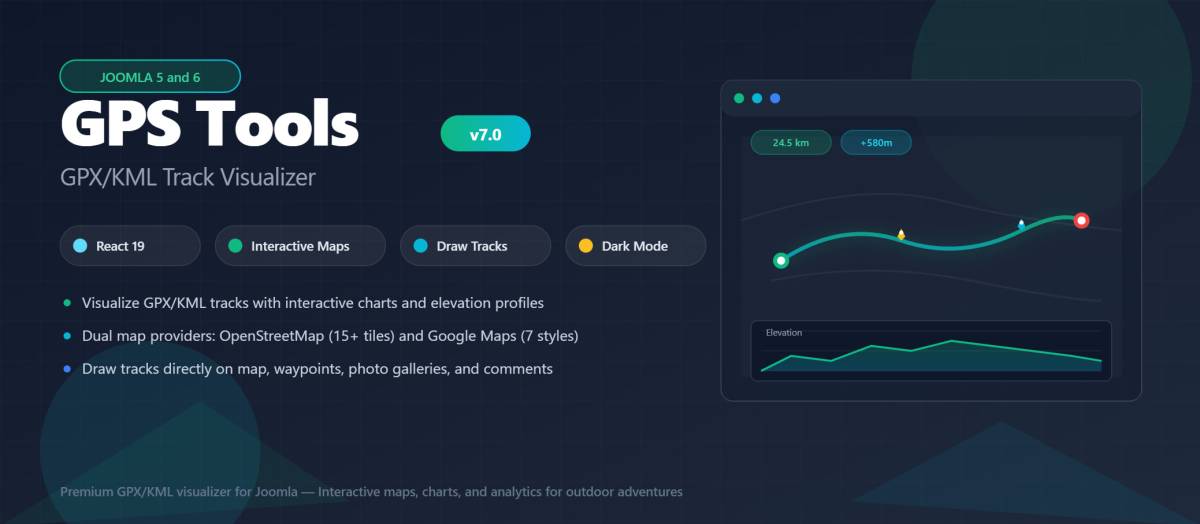
Track Visualization
- Interactive maps with OpenStreetMap and Google Maps
- Elevation-colored track lines
- Start/end point markers
- Waypoint display with custom icons
- Fullscreen mode
Charts & Analytics
- Elevation profile chart
- Speed over distance chart
- Heart rate chart
- Hover-to-highlight functionality
Statistics
- Distance, duration, elevation gain/loss
- Average and maximum speed
- Difficulty rating
- Activity type classification
File Support
- GPX (GPS Exchange Format)
- KML (Google Earth)
- TCX (Garmin Training Center)
Why We Built GPS Tools
The outdoor and fitness community has exploded in recent years. Millions of people track their activities with GPS devices and apps, creating valuable data that tells the story of their adventures.
But sharing these tracks on a website? That's been surprisingly difficult. Existing solutions are either too basic (just showing a static image) or too complex (requiring developer expertise).
GPS Tools bridges that gap. Upload your GPX file, and within seconds you have a professional, interactive visualization that your visitors will love.
What Can You Do With GPS Tools?
Display Tracks on Interactive Maps
Choose between OpenStreetMap (free, no API key needed) or Google Maps. Your tracks display with smooth elevation-colored lines that show the terrain at a glance.
Analyze with Detailed Charts
GPS Tools automatically generates beautiful charts:
- Elevation Profile - See the ups and downs
- Speed Over Distance - Understand pace variations
- Heart Rate - Analyze training intensity (if data available)
Hover over any point on the chart, and the corresponding location highlights on the map. It's an intuitive way to explore track data.
Get Comprehensive Statistics
At a glance, visitors see:
- Total distance
- Elevation gain and loss
- Duration and moving time
- Average and maximum speed
- Difficulty rating
No manual calculations needed - GPS Tools extracts everything automatically.
Included Extensions
GPS Tools is a complete solution:
| Extension | Description |
|-----------|-------------|
| com_gpstools | Main component for track management |
| modgpstoolsmap | Display a map with multiple track locations |
| modgpstoolstracks | List tracks with thumbnails and stats |
| plgfindergpstools | Smart Search integration |
| plgcontentgpstools | Shortcode support for articles |
One package, everything included.
Modern Technology
Built with React 19, TypeScript, Chart.js, and Tailwind CSS. Fully responsive on all devices.
Use Cases
Hiking Websites
Share trails with difficulty ratings and elevation profiles. Help visitors prepare for their adventure.
Cycling Clubs
Display club routes, organize group rides, and track popular paths in your area.
Running Communities
Showcase routes with pace information and terrain analysis.
Tourism Portals
Promote outdoor activities with professional-quality visualizations.
Adventure Blogs
Bring trip reports to life with interactive maps and charts.
Fitness Platforms
Share workouts with detailed performance data.
GPS Tools is a comprehensive GPS track visualization component for Joomla 5 and 6. If you've ever wanted to display hiking trails, cycling routes, or running paths on your Joomla website, GPS Tools makes it beautiful and easy.
Extension Data :
- Compatibility :
- Joomla 3.xYes
- Joomla 4.xYes
- Joomla 5.xYes
- Joomla 6.xYes